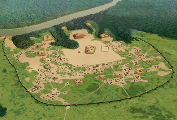
Twenty-nine mounds around a plaza, the centre of a chiefdom for five centuries
Moundville stands on a bluff over the Black Warrior River in Hale County, Alabama, near Tuscaloosa: 29 platform mounds set around a great rectangular plaza, the second-largest site of the classic Middle Mississippian era in the United States after Cahokia. Between the 11th and 16th centuries it was the political and ceremonial centre of a regional chiefdom known as the Province of Pafalaya.
People of the Mississippian culture lived here from around 1000 AD. Around 1150 the settlement's leaders began to turn it from a local into a regional centre, and after 1200 they raised the mounds and the plaza. At its height the town covered some 300 acres, walled on three sides by a bastioned wooden palisade and on the fourth by the river bluff, with perhaps 1,000 to 3,000 people inside and 10,000 more in the valley around, living on surplus maize and trading for luxury goods. The biggest mounds rise on the north side of the plaza and grow smaller as they run round to the south. Mound B, just north of Mound A at the centre, is a steep pyramid 58 feet high with two ramps. Archaeologists read the plan as a sociogram, a social order of ranked clans drawn in earth, with the highest clans on the largest northern mounds. By 1300 the place was more a religious and political centre than a town, and by 1500 most of it was empty.
The ground still holds more than anyone has dug. A landscape-scale magnetic survey led by Jera Davis, Chester Walker and John Blitz of the University of Alabama mapped more than 450 unexcavated probable buildings beneath the site, nearly five times as many as decades of traditional excavation had found.
Clarence Bloomfield Moore, a Philadelphia lawyer, dug extensively in 1906 and kept careful records; looters followed for two decades. In the mid-1920s the geologist Walter B. Jones and other concerned citizens, with the Alabama Museum of Natural History, bought the land. Civilian Conservation Corps crews stabilised the mounds in the Depression, and the park opened in 1939 with the Jones Archaeological Museum, remodelled in 2010. In a 1980 break-in thieves took 264 pottery vessels, a fifth of the collection and the best of it; none surfaced until three ceremonial bowls were returned anonymously in 2018. In 2021 a federal review committee found the site culturally linked to seven Muskogean-speaking tribes seeking the return of 5,982 human remains and funerary objects.
The University of Alabama Museums run the 185-acre park, a National Historic Landmark since 1964, with a museum, a working archaeology lab and summer field seasons.
Commons photos · Atlas Obscura · US National Register · OpenStreetMap
Other places on the map within a couple of hours.
