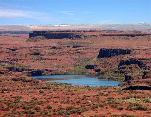
Bare basalt scoured by more than forty cataclysmic floods
The Channeled Scablands are a stretch of southeastern Washington, some 1,500 to 2,000 square miles, where the soil is largely gone and the old basalt lava flows lie bare, cut by dry channels, coulees and abandoned waterfalls. River valleys are V-shaped and glacial ones U-shaped, but these channels have a rectangular cross section, flat plateaus between steep walls, and they braid and rejoin across the land in a pattern that runs from the northeast to the southwest. Buttes stand 30 to 230 metres high between rock basins up to Rock Lake, 11 km long. There are potholes drilled by whirling vortices called kolks, giant current ripples from 1 to 15 metres high, and boulders carried far from home on ice.
Floods did it. At the end of the last ice age, about 18,000 to 15,000 years ago, a lobe of the Cordilleran ice sheet dammed the Clark Fork River in northern Idaho, and Glacial Lake Missoula rose 2,000 feet behind it and stretched 200 miles east. When the dam failed it let go, by the Park Service's figure, as much as 600 cubic miles of water in about two days, a wall hundreds of feet high moving at 65 miles an hour across 16,000 square miles of Montana, Idaho, Washington and Oregon. The ice dam formed and burst again and again: more than 40 floods during the Last Glacial Maximum, and many older ones over the past two million years, the oldest perhaps before 1.5 million years ago. The last came between about 18,200 and 14,000 years ago.
For decades geologists refused to believe it. J Harlen Bretz, a high school teacher turned geology professor, began fieldwork here in 1922 and argued through the 1920s for short, immense floods, of around 500 cubic miles, but he had no source for the water, and the profession, committed to slow, gradual change, fought him. Joseph Pardee of the US Geological Survey had already found the high water marks of an ancient lake near Missoula, suggested a glacial lake to Bretz in 1925, and spent the next 30 years building the case, finding giant ripple marks on the old lake bed. Hydraulics research in the 1970s settled it, and in 1979 Bretz received the Geological Society of America's highest award, the Penrose Medal.
The scablands are now part of the Ice Age Floods National Geologic Trail, and planetary scientists study them as perhaps the best match on Earth for the outflow channels of Mars.
Other places on the map within a couple of hours.
