The biggest post on the northern plains, and the buffalo went out through it
Fort Pierre Chouteau stood on a low terrace on the west bank of the Missouri, just north of where the Bad River comes in, in what is now central South Dakota. Europeans had marked the spot early. In 1743 the La Vérendrye brothers buried an inscribed lead plate on a hill above the confluence, claiming the land for the King of France, and Lewis and Clark camped nearby in 1804.
The fur trade came next. Joseph La Framboise opened a trading post here in 1817, the Columbia Fur Company built Fort Tecumseh on a flood-prone island, and in 1827 John Jacob Astor's American Fur Company bought them out. In 1832 Pierre Chouteau Jr. of St. Louis came up the river on the maiden voyage of the steamboat Yellowstone and ordered a new post built, partly from Fort Tecumseh's timbers, and named Fort Pierre after him. When Astor retired in 1834, Chouteau bought the operation.
It became one of the largest and best-equipped posts on the northern Great Plains, halfway between St. Louis and the company's northernmost forts and the head of an overland route to Fort Laramie. Lakota and other Plains peoples camped around it to trade buffalo robes for American and European goods. Prince Maximilian, visiting in 1833, put each side of the stockade at about 300 feet; George Catlin had come the year before, and John J. Audubon followed a decade later. At its height in the 1850s, the company shipped 100,000 buffalo robes through it to markets in the East and in Europe, while the herds collapsed under the hunting.
In the mid-1850s the United States Army bought the fort, its first military post on the upper Missouri, and spent nearly $20,000 on repairs, but found it so decrepit that it abandoned it in 1857 for Fort Randall. Usable buildings went downriver and the leftover timbers were burned as steamboat fuel. The land became part of the Sioux reservation under the 1868 Treaty of Fort Laramie, was opened to homesteaders after 1889, served as pasture and was bought by the state in 1930.
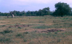
Nothing of the fort stands today. Its site is an open meadow just north of the town of Fort Pierre, off Fort Chouteau Road, with a stone marker reached by a gravel path. Excavations in 1980 and from 1997 to 2001 turned up coins, pottery, fabric, wooden remnants of the walls and moccasins, and the site became a National Historic Landmark in 1991. The Vérendrye plate resurfaced in 1913, when schoolchildren found it sticking out of the hill and nearly sold it for scrap; it is on display in Pierre.
Commons photos · US National Register · Britannica · OpenStreetMap
Other places on the map within a couple of hours.
